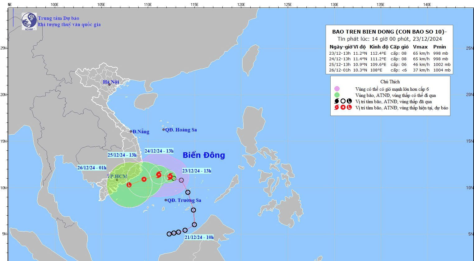
Storm details and forecast trajectory
According to the National Center for Hydro-Meteorological Forecasting, by 1:00 PM on December 23, 2024, the storm's center was located at approximately 11.2°N latitude and 112.4°E longitude, near the northwest of the Spratly Islands.
Its strongest winds reached level 8 (62–74 km/h) with gusts of level 10.
The storm is moving west-northwest at a slow pace of 5–10 km/h.
Next 24 hours: By 1:00 PM on December 24, the storm is expected to be in the southwestern Middle East Sea. Its strength will remain at level 8, with gusts of level 10.
Following 24 hours: The storm will shift west-southwest, weaken into a tropical depression, and reach the sea area between Phu Yen and Ba Ria-Vung Tau by 1:00 PM on December 25. At this point, wind speeds will reduce to level 6, with gusts of level 8.
ubsequent 12 hours: The tropical depression will further weaken into a low-pressure system over the coastal waters between Binh Thuan and Tra Vinh.
Rainfall and potential impacts
The storm has already caused scattered rain in the Central region, with more expected:
From December 23 night to December 24 night:
Da Nang to Khanh Hoa: Moderate to heavy rain (40–120mm), with localized areas exceeding 200mm.
Eastern Central Highlands: Rainfall of 30–60mm, with localized areas over 100mm.
On December 25: Central and South-Central regions, Eastern Central Highlands: Rainfall of 40–80mm, with some areas over 150mm.
From December 26, rainfall is expected to decrease across affected areas.
The meteorological agency warns of thunderstorms accompanied by lightning, whirlwinds, and strong winds. Prolonged heavy rain could lead to urban flooding in low-lying areas, flash floods in small rivers and streams, and landslides in hilly regions.
Maritime warnings
The storm has intensified conditions in the following areas:
Northern South East Sea (including the northern Spratly Islands) and southwestern Middle East Sea: Strong winds (level 6–7), reaching level 8 with gusts of level 10 near the storm's center.Waves range from 4–6 meters, creating hazardous conditions.
Mariners are advised to avoid these areas, as high winds, thunderstorms, and large waves pose significant risks to vessels.
Bao Anh